From solving the problems of lost communication to empowering the next generation Communication/Navigation System
One year after the incidence of missing Malaysia Airlines Flight MH370, the pertinent question, whether this mishap could have been avoided, still remains the same. Unanswered questions such as why the air-to-ground communication system was disabled, why the aircraft lost the navigation path are still the mystery. But this is not the first time a plane has gone missing. Many such events have occurred including the missing AirAsia Flight QZ8501, missing planes in Bermuda Triangle, and the missing Air France Flight 447. This raises the question whether navigation systems can evolve enough to solve this problem in future. Leading aviation players are working on different technologies to make navigation more real-time and we look to the future for safer air travel.
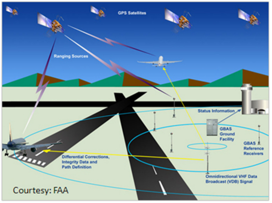
There has always been a need for a more efficient system to solve the problem of lost communication. The leading players across the globe have worked out the concept of Global Navigation Satellite System (GNSS) that would have alternate connectivity with satellite along with the ground station and the plane so that either could be traced through one of the connections. Currently, three Global Navigation Satellite Systems (GNSS) are in operation: the United States’ Global Positioning System (GPS); Russian Federation’s Global Orbiting Navigation Satellite System (GLONASS) and Europe’s Galileo System. The GNSS transmitter sends signals to aircraft via satellites if communication between flight and ground station is broken. A GNSS receiver tracks all visible satellites. If some satellites are blocked by major obstacles, the receiver will automatically try to reacquire the blocked signals using other available satellites. The GNSS receiver provides a three-dimensional solution (latitude, longitude, and altitude) for the same.
The Flight Decks have replaced their mechanical instruments, computer screen look and feel, and warning lights with the GNSS navigation system. The system will now be able to display precise results about the vehicle positioning map with flight plans, 3D Navigation maps, traffic and landing.
China had recently come up with “Three-in-one” airborne broad band communication platform, integrating the mobile phone, internet and television network. Aircrafts can transmit sensor data as well as flight status to the ground in real-time via data interfaces of FMC (Flight Management System) or flight data recorder. This technology supports Beidou (GNSS) and GPS dual-mode and can collect such information on aircraft position, speed, route and attitude in real-time. IP Cameras are also installed in aircraft cockpits to get real-time videos & images. In case of failure or abnormal circumstances, expert members from the base station can do visual and verbal communication with the pilot too.

With the increasing per capita income, the number of people opting for airways has increased. The economies of scale have further increased the competition between the major players to cut down on the cost and leverage on the volumes. With GNSS and other alternative technology coming through, people are hopeful that the new system would not just solve the problem of increasing traffic but also ensure safer flight conditions. The future lies in real-time tracking through intelligent systems rather than depending on the ground station for instructions.
eInfochips has been working with multiple players on developing GNSS-based navigation and communication systems. With DO-254, DO-178B/C, ARP4754 practice standards expertise in house, eIfochips is working on developing the next-generation iridium-based satellite communication system as well as GNSS system. We commit ourselves to explore and bring the best in the industry.


